

Good morning from Central Florida, where there’s a tropical storm warning in effect, and the rain is currently falling furiously against the windows. Tropical Storm Isaias is moving up the Atlantic coastline, and it’s another wonderful day in hurricane season!
If you heard very little about theme park prep for Hurricane/Tropical Storm Isais compared to recent storms, that’s because this one was never expected to impact the Orlando area with more than tropical storm-force winds. Even as a hurricane, Isaias was not forecast to pack much of a punch for the interior of Florida. More on the rain and wind risks a tropical storm can pose for your vacation below. Right now, let’s talk about how we’re replacing an incredibly hot final week of July with a soggy first week of August… even by Floridian standards.
This week’s weather at Walt Disney World
The slow movement of Tropical Storm Isaias will continue up the Atlantic coast, with the center coming close to Cape Canaveral late Sunday night. Look for increasing winds throughout Sunday, switching from northeast to north. Winds will be sustained at 15 to 20 miles per hour, with gusts up to 25 miles per hour. The scattered rain and storms will continue to move through quickly, with a high in the upper 80s and a low tonight around 77.
Monday, Isaias will be slowly pulling north from the area. There’s still a strong chance the tropical weather will be hanging around for your wake-up call. The possibility of lingering rain bands will give way to a strong westerly flow. Heat, humidity, and the west wind will spark scattered to numerous afternoon thunderstorms. Expect a high of 91 degrees, with an overnight low of 76.
Isaias leaves behind a moist atmosphere, and this plus a trough of low pressure gives us a very stormy forecast for the rest of the week. Tuesday through Saturday, the daily forecast is for a high near 93 degrees, a low around 76, and an impressive 80% chance of thunderstorms.

Tropical Weather Outlook
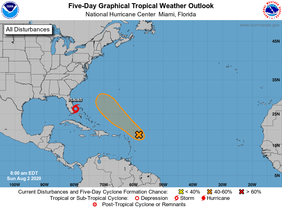
What comes next after Tropical Storm Isaias moves north? The next area of interest for the National Hurricane Center is a tropical wave just east of the Leeward Islands. While this cluster of storms has not been quick to organize, it’s entering a favorable weather pattern and as it continues to move northwest over the Atlantic, it is expected to become a tropical depression midweek. The formation chance through the next five days is 60%.
How Serious is a Tropical Storm?
Tropical storms can be extremely dangerous storms, with flooding, wind, and tornado hazards. Strong tropical storms can cause downed trees, knocking out power and blocking roads, and cause flash floods which inundate communities. They can also be little more than blustery days with some rain. It all depends on where you are, where the center of the storm is, and how well-organized the storm is.
Tropical storms which just brush the Orlando area can bring clouds alternating with watery sunshine and squally storms which blow through quickly. The outer rain bands of tropical systems produce weather that’s very distinctive from normal Florida storms. These short bursts of heavy rain with gusty winds arrive quickly and depart just as swiftly, unlike a heavy afternoon thunderstorm which might hang out in the area for a few hours, dumping inches of rain, gusty winds, and frequent lightning.

In tropical storm squalls, thunderstorms with lightning tend be embedded cells in heavier rain bands, rather than huge sprawling complexes of storms which we get so used to in summer.
As we are far from the weakening core of Tropical Storm Isaias, and with an atmosphere which currently doesn’t favor tornado development, there is a similar level of risk to venturing outdoors today as there would be any other day in the summer.
So you can often enjoy a day at the theme parks even when there’s a tropical storm in the area, and generally face very little risk other than getting extremely wet. This could vary of course—a strong, well-organized tropical storm moving directly through Orlando could have severe effects and would prompt a response from theme parks. It’s important to remember every storm is its own individual situation, and plan for risks accordingly.
The post This Week in Walt Disney World Weather — August 2, 2020 appeared first on TouringPlans.com Blog.